Ki-demang.com : Candi

Kaca Ngajeng Candhi

ikon-kaca-ngajeng
 

ikon-buku-tamu

candi-prov-yogyakarta

candi-sleman
candi-bantul
candi-gunung-kidul
candi-kulon-progocandi-kota-yogyakarta


 candi-prov-jawa-tengah
candi-klaten
candi-magelang
candi-boyolali
candi-temanggung
candi-kabupaten-semarang
candi-banyumas
candi-wonosobo
candi-kota-semarang
candi-kendal
candi-banjarnegara
candi-batang
candi-pemalang
candi-tegal
candi-brebes
candi-purwodadi
candi-kudus
candi-purworejo
 candi-purbalingga
candi-kebumen

    Jumlah Pengunjung

0463471
  Hari ini     :  Hari ini :134
  Kemarin     :  Kemarin :141
  Minggu ini   :  Minggu ini :270
  Bulan ini   :  Bulan ini :2887
  s/d hari ini   :  s/d hari ini :463471
Pengunjung Online : 11

Kontak Admin.

email-kidemang

61 Ratu Boko

situs ratuboko wiki01

http://upload.wikimedia.org/wikipedia/commons/0/07/Ratu_Boko_temple.JPG


situs ratuboko pnri01

http://candi.pnri.go.id/jawa_tengah_yogyakarta/ratubaka/image/BARAT_05220001.jpg


Candi Baka terletak sekitar 3 km ke arah selatan dari Candi Prambanan atau sekitar 19 km ke arah selatan dari kota Yogyakarta. Kawasan Candi Ratu Baka yang berlokasi di atas sebuah bukit dengan ketinggian ± 195.97 m diatas permukaan laut, meliputi dua desa, yaitu Desa Sambirejo dan Desa Dawung.

Situs Ratu Baka sebenarnya bukan merupakan candi, melainkan reruntuhan sebuah kerajaan. Oleh karena itu, Candi Ratu Baka sering disebut juga Kraton Ratu Baka. Disebut Kraton Baka, karena menurut legenda situs tersebut merupakan istana Ratu Baka, ayah Lara Jonggrang. Kata 'kraton' berasal dari kata Ka-ra-tu-an yang berarti istana raja. Diperkirakan situs Ratu Baka dibangun pada abad ke-8 oleh Wangsa Syailendra yang beragama Buddha, namun kemudian diambil alih oleh raja-raja Mataram Hindu. Peralihan 'pemilik' tersebut menyebabkan bangunan Kraton Baka dipengaruhi oleh Hinduisme dan Buddhisme.

Kraton Ratu Baka ditemukan pertama kali oleh arkeolog Belanda, HJ De Graaf pada abad ke-17. Pada tahun 1790 Van Boeckholtz menemukan kembali reruntuhan bangunan kuno tersebut. Penemuannya dipublikasikan sehingga menarik minat para ilmuwan seperti Makenzie, Junghun, dan Brumun yang melakukan pencatatan di situs tersebut pada tahun 1814. Pada awal abad ke-20, situs Ratu Baka diteliti kembali oleh FDK Bosch. Hasil penelitiannya dilaporkan dalam tulisan berjudul Keraton Van Ratoe Boko. Ketika Mackenzie mengadakan penelitian, ia menemukan sebuah patung yang menggambarkan seorang laki-laki dan perempuan berkepala dewa sedang berpeluk-pelukan. Dan di antara tumpukan batu juga diketemukan sebuah tiang batu bergambar binatang-binatang, seperti gajah, kuda dan lain-lain.

Di situs Ratu Baka ditemukan sebuah prasasti berangka tahun 792 M yang dinamakan Prasasti Abhayagiriwihara. Isi prasasti tersebut mendasari dugaan bahwa Kraton Ratu Baka dibangun oleh Rakai Panangkaran. Prasasti Abhayagiriwihara ditulis menggunakan huruh pranagari, yang merupakan salah satu ciri prasasti Buddha. Dalam prasasti itu disebutkan bahwa Raja Tejapurnama Panangkarana, yang diperkirakan adalah Rakai Panangkaran, telah memerintahkan pembangunan Abhayagiriwihara. Nama yang sama juga disebut-sebut dalam Prasasti Kalasan (779 M), Prasati Mantyasih (907 M), dan Prasasti Wanua Tengah III (908 M). Menurut para pakar, kata abhaya berarti tanpa hagaya atau damai, giri berarti gunung atau bukit. Dengan demikian, Abhayagiriwihara berarti biara yang dibangin di sebuah bukit yang penuh kedamaian. Pada pemerintahan Rakai Walaing Pu Kombayoni, yaitu tahun 898-908, Abhayagiri Wihara berganti nama menjadi Kraton Walaing.

Kraton Ratu Baka yang menempati lahan yang cukup luas tersebut terdiri atas beberapa kelompok bangunan. Sebagian besar di antaranya saat ini hanya berupa reruntuhan.


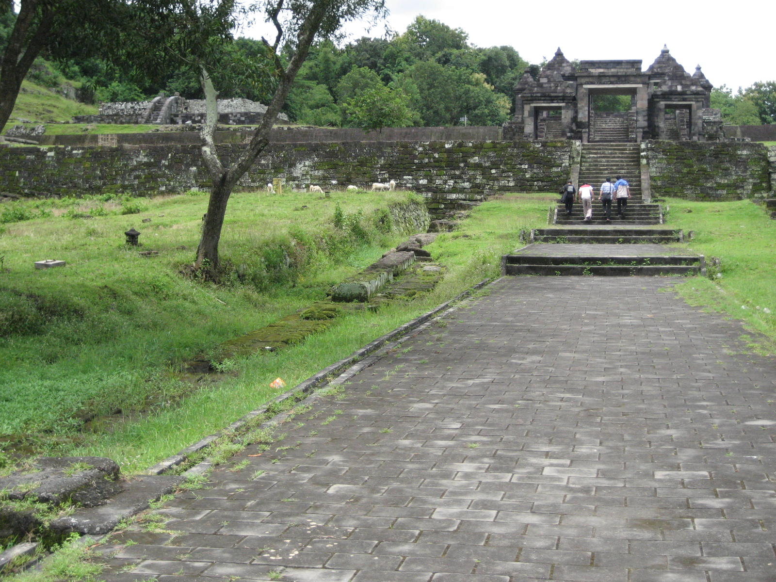
Gerbang

Gerbang masuk ke kawasan wisata Ratu Baka terletak di sisi barat. Kelompok gerbang ini terletak di tempat yang cukup tinggi, sehingga dari tempat parkir kendaraan, orang harus melalui jalan menanjak sejauh sekitar 100 m. Pintu masuk terdiri atas dua gerbang, yaitu gerbang luar dan gerbang dalam. Gerbang dalam, yang ukurannya lebih besar merupakan gerbang utama.


situs ratuboko pnri02

http://candi.pnri.go.id/jawa_tengah_yogyakarta/ratubaka/image/BARAT_05220003.jpg


situs ratuboko pnri03

Sekitar 15 m dari gerbang luar berdiri gerbang dalam atau gerbang utama. Gerbang ini terdiri atas 5 gapura paduraksa yang bebaris sejajar dengan gerbang luar. Gapura utama diapit oleh dua gapura pengapit di setiap sisi.

http://candi.pnri.go.id/jawa_tengah_yogyakarta/ratubaka/image/BARAT_05220007.jpg


situs ratuboko pnri04

Walaupun gerbang dalam ini terdiri atas lima gapura, namun tangga yang tersedia hanya tiga. Dua gapura pengapit yang kecil tidak dihubungkan dengan tangga.

http://candi.pnri.go.id/jawa_tengah_yogyakarta/ratubaka/image/BARAT_05220009.jpg


Gerbang luar terdiri atas 3 gapura paduraksa yang berjajar arah utara-selatan, berhimpitan menghadap ke timur. Gapura terbesar, yang merupakan gapura utama, terletak di antara dua gapura pengapit. Ketiga gapura tersebut terletak di teras yang tinggi, sehingga untuk sampai ke pelataran teras orang harus menaiki dua tangga batu, masing-masing setinggi sekitar 2,5 m. Dinding teras diberi penguat berupa turap yang terbuat dari susunan batu andesit. Tak satupun dari ketiga gapura tersebut yang atapnya masih utuh, sehingga tidak diketahui bentuk aslinya. 


Sekitar 15 m dari gerbang luar berdiri gerbang dalam atau gerbang utama. Gerbang ini terdiri atas 5 gapura paduraksa yang bebaris sejajar dengan gerbang luar. Gapura utama diapit oleh dua gapura pengapit di setiap sisi. Walaupun gerbang dalam ini terdiri atas lima gapura, namun tangga yang tersedia hanya tiga. Dua gapura pengapit yang kecil tidak dihubungkan dengan tangga. Tangga naik dilengkapi dengan pipi tangga dengan hiasan 'ukel' (gelung) di pangkal dan kepala raksasa di puncak pipi tangga. Dinding luar pipi tangga juga dihiasi dengan pahatan bermotif bunga dan sulur-suluran. Atap gapura utama sudah hilang sehingga tidak diketahui bentuk aslinya, namun atap gapura pengapit yang masih utuh berbentuk limasan dengan puncak berbentuk ratna.


situs ratuboko pnri05

Tangga naik dilengkapi dengan pipi tangga dengan hiasan 'ukel' (gelung) di pangkal dan kepala raksasa di puncak pipi tangga.

http://candi.pnri.go.id/jawa_tengah_yogyakarta/ratubaka/image/BARAT_05220015.jpg


situs ratuboko pnri06

Dinding luar pipi tangga juga dihiasi dengan pahatan bermotif bunga dan sulur-suluran.

http://candi.pnri.go.id/jawa_tengah_yogyakarta/ratubaka/image/BARAT_05220021.jpg


Candi Batukapur

Sekitar 45 m dari gerbang pertama, ke arah timur laut, terdapat fondasi berukuran 5x5 m2 yang dibangun dari batu kapur. Diperkirakan bahwa dinding dan atap bangunan aslinya tidak terbuat dari batu, melainkan dari bahan lain yang mudah rusak, seperti kayu dan sirap atau genteng biasa.


Candi pembakaran

Candi pembakaran berbentuk teras tanah berundak setinggi 3 m. Letaknya sekitar 37 m ke arah timur laut dari gerbang utama. Bangunan ini berdenah dasar bujur sangkar dengan luas 26 m2. Teras kedua lebih sempit dari teras pertama, sehingga membentuk selasar di sekeliling teras kedua. Permukaan teras atas atau teras kedua merupakan pelataran rumput. Dinding kedua teras berundak tersebut diperkuat dengan turap dari susunan batu kali. Di sisi barat terdapat tangga batu yang dilengkapi dengan pipi tangga. Di tengah pelataran teras kedua terdapat semacam sumur berbentuk bujur sangkar dengan ukuran 4X4 m2 yang digunakan sebagai tempat pembakaran mayat.

Di sudut tenggara candi pembakaran terdapat salah satu sumur tua yang konon merupakan sumber air suci.


situs ratuboko pnri07

Permukaan teras atas atau teras kedua merupakan pelataran rumput. Dinding kedua teras berundak tersebut diperkuat dengan turap dari susunan batu kali. Di sisi barat terdapat tangga batu yang dilengkapi dengan pipi tangga. Di tengah pelataran teras kedua terdapat semacam sumur berbentuk bujur sangkar dengan ukuran 4X4 m2 yang digunakan sebagai tempat pembakaran mayat.

http://candi.pnri.go.id/jawa_tengah_yogyakarta/ratubaka/image/UTARA_TIMUR_05220028.jpg


situs ratuboko pnri08

Candi pembakaran berbentuk teras tanah berundak setinggi 3 m. Letaknya sekitar 37 m ke arah timur laut dari gerbang utama. Bangunan ini berdenah dasar bujur sangkar dengan luas 26 m2.

http://candi.pnri.go.id/jawa_tengah_yogyakarta/ratubaka/image/BARAT_05220030.jpg


situs ratuboko pnri09

Di sudut tenggara candi pembakaran terdapat salah satu sumur tua yang konon merupakan sumber air suci.

http://candi.pnri.go.id/jawa_tengah_yogyakarta/ratubaka/image/TIMUR_05220022.jpg


Paseban

Paseban merupakan kata dalam bahasa Jawa yang berarti tempat untuk menghadap raja (seba = menghadap). Bangunan ini terletak sekitar 45 m ke arah selatan dari gapur. Paseban merupakan teras yang dibangun dari batu andesit dengan tinggi 1,5 m, lebar 7 m dan panjang 38 m, membujur arah utara-selatan. Tangga naik ke lantai paseban terletak di sisi barat. Di berbagai tempat di permukaan lantai ditemukan 20 umpak fondasi tempat menancapkan tiang bangunan) dan 4 alur yang diperkirakan bekas tempat berdirinya dinding pembatas.


situs ratuboko pnri10

http://candi.pnri.go.id/jawa_tengah_yogyakarta/ratubaka/image/SELATAN_05220037.jpg


Pendapa

Sekitar 20 m dari paseban, arah selatan dari gapura, terdapat dinding batu setinggi setinggi 3 m yang memagari sebuah lahan dengan ukuran panjang 40 m dan lebar 30 m. Di sisi utara, barat dan selatan pagar tersebut terdapat jalan masuk berupa gapura paduraksa (gapura beratap).


situs ratuboko pnri11

http://candi.pnri.go.id/jawa_tengah_yogyakarta/ratubaka/image/PENDOPO_UTARA_05220061.jpg


situs ratuboko pnri12

Di sisi utara, barat dan selatan pagar pendapa terdapat jalan masuk berupa gapura paduraksa (gapura beratap).

http://candi.pnri.go.id/jawa_tengah_yogyakarta/ratubaka/image/PENDOPO_BARAT_05220044.jpg


situs ratuboko pnri13

Di beberapa tempat di bagian luar dinding terdapat saluran pembuangan air, yang disebut jaladwara. Jaladwara ditemukan juga di candi Banyuniba dan Barabudhur.

http://candi.pnri.go.id/jawa_tengah_yogyakarta/ratubaka/image/PENDOPO_BARAT_05220043.jpg


Di beberapa tempat di bagian luar dinding terdapat saluran pembuangan air, yang disebut jaladwara. Jaladwara ditemukan juga di candi Banyuniba dan Barabudhur.

Dalam pagar batu tersebut terdapat dua teras yang dibangun menggunakan batu susunan andesit. Sepanjang tepi dinding dan di antara dua teras terdapat gang berlantai batu. Teras pertama disebut pendapa, berbentuk semacam panggung persegi setinggi 1,46 m, dengan ukuran luas 20 m2. Dalam bahasa Jawa, pendapa berarti ruang tamu atau hamparan lantai beratap yang umumnya terletak di bagian depan rumah. Tangga naik ke pendapa berada di sisi timurlaut dan baratlaut.

Diatas permukaan lantai pendapa terdapat 24 buah umpak batu.Teras kedua, yang disebut 'pringgitan' terletak di selatan pendapa. Pringgitan artinya ruang dalam atau ruang duduk. Pringgitan ini juga berdenah segi empat dengan luas 20 X 6 m. Di permukaan lantai pringgitan ditemukan 12 umpak batu.


situs ratuboko pnri14

http://candi.pnri.go.id/jawa_tengah_yogyakarta/ratubaka/image/PENDOPO_DALAM_BARAT_0522004.jpg


situs ratuboko pnri15

Teras kedua, yang disebut 'pringgitan' terletak di selatan pendapa. Pringgitan artinya ruang dalam atau ruang duduk. Pringgitan ini juga berdenah segi empat dengan luas 20 X 6 m. Di permukaan lantai pringgitan ditemukan 12 umpak batu.

http://candi.pnri.go.id/jawa_tengah_yogyakarta/ratubaka/image/PENDOPO_DALAM_05220048.jpg


Tempat pemujaan

Di luar dinding pendapa, arah tenggara, terdapat sebuah teras batu yang masih utuh. Di ujungnya terdapat 3 buah candi kecil yang digunakan sebagai tempat pemujaan. Bangunan yang di tengah, yang berukuran lebih besar dibandingkan dengan kedua candi pengapitnya, adalah tempat untuk memuja Dewa Wisnu. Kedua candi yang mengapitnya, masing-masing, merupakan tempat memuja Syiwa dan Brahma.


situs ratuboko pnri16

http://candi.pnri.go.id/jawa_tengah_yogyakarta/ratubaka/image/PEMUJAAN_BARAT_05220052.jpg


situs ratuboko pnri17

http://candi.pnri.go.id/jawa_tengah_yogyakarta/ratubaka/image/PEMUJAAN_05220053.jpg


Keputren

Keputren yang artinya tempat tinggal para putri letaknya di timur pendapa. Lingkungan keputren seluas 31 X 8 m dibatasi oleh pagar batu setinggi 2 m, namun sebagian besar pagar batu tersebut telah runtuh. Pintu masuk, berupa gapura paduraksa dengan hiasan Kalamakara di atas ambangnya, terletak di sisi timur dan barat.

Lingkungan keputren terbagi dua oleh tembok batu yang memiliki sebuah pintu penghubung. Dalam lingkungan pertama terdapat 3 buah kolam berbentuk persegi. Yang sebuah berbentuk bujur sangkar, berukuran lebih besar dibandingkan kedua kolam lainnya. Dua kolam yang lebih panjang bebentuk persegi panjang membujur arah utara-selatan.

Dalam lingkungan yang bersebelahan dengan tempat ketiga kolam persegi di atas berada, terdapat 8 kolam berbentuk bundar yang berjajar dalam 3 baris.


situs ratuboko pnri18

http://candi.pnri.go.id/jawa_tengah_yogyakarta/ratubaka/image/KEPUTREN_UTARAN_05220057.jpg


situs ratuboko pnri19

http://candi.pnri.go.id/jawa_tengah_yogyakarta/ratubaka/image/KEPUTREN_BARAT_SELATAN_0522.jpg


Gua

Di lereng bukit tempat kawasan Ratu Baka berada, terdapat dua buah gua, yang disebut Gua Lanang dan Gua Wadon (gua lelaki dan gua perempuan). Gua Lanang yang terletak di timur laut 'paseban' merupakan lorong persegi dengan tinggi 1,3 m, lebar 3,7 m dan dalam 2,9 m. Di dalam gua, masing-masing di sisi kiri, kanan dan belakang, terdapat relung seperti bilik. Pada dinding gua terdapat pahatan berbentuk semacam pigura persegi panjang. Mackenzie menemukan patung di depan Gua Lanang ini.

Gua Wadon yang terletak sekitar 20 m ke arah tenggara dari 'paseban' lebih kecil ukurannya dibandingkan dengan Gua Lanang, yaitu tinggi 1,3 m, lebar 3 dan dalam 1, 7 m. Di bagian belakang gua terdapat relung seperti bilik.


situs ratuboko pnri20

http://candi.pnri.go.id/jawa_tengah_yogyakarta/ratubaka/image/GUA_05220067.jpg


situs ratuboko pnri21

http://candi.pnri.go.id/jawa_tengah_yogyakarta/ratubaka/image/GUA_DALAM_05220068.jpg


Sumber : http://candi.pnri.go.id/jawa_tengah_yogyakarta/ratubaka/ratubaka.htm


Administrative localization:

Dawung, Bokoharjo, Prambanan, Sleman, DIY.


Geographical localization:
Western compound, 2d terrace gopura:
07° 46' 07.4'' S
110° 29' 18.6'' E
Precision: 6m
Southeastern compound, 2d terrace, miniature candi:
07° 46' 18.7'' S
110° 29' 26.0'' E
Precision: 7m
Alt: 160m – 200m


Surroundings:

On the top of a high hill rising from the lowland and protected by steep slopes. Parts of the hill have been made flat to house this vast compound. From the various buildings, one can see Mount Merapi, the Prambanan plain, the Yogyakarta plain, the Opak River, Mount Pegat, Mount Ijo and other areas of Gunung Kidul. The site is located 700m to the west southwest of Sumberwatu and Arca Ganeça, 750m to the north northwest of Banyunibo, 800m to the northwest of Dawangsari and Barong, 900m to the north of Semarangan, 1000m to the northeast of Watugudig and 1200m to the east northeast of Ngaglik.


Religion: Hindu and Buddhist.
Main features: Organic compound; facing west; no main structure.
State of preservation: Most of the structures seem to have been built out of wood and only their stone bases remains. The complex is undergoing restoration work.


Description:

The site of Ratu Boko is made out of three compounds: the western, the eastern and the southeastern compounds.
o The western compound is composed of three terraces.
The first and westernmost terrace is a wide area, roughly 100m long, sloping down to the west. Its soil is made from natural rock covered by dust.
The only remains visible are located at the eastern end of the terrace and are those of a ramp leading to the second terrace.
The second terrace is sustained by an impressive 5m high retaining wall. The wall is running north south. Another retaining wall, running east west, extends it and links the western compound with the southeastern compound.
In its northern part, the second terrace is divided into two elongated courtyards separated by a wall.115
The western courtyard is 10m large and shelters no remains.
The wall demarcating the western and eastern courtyard is interrupted by an impressive 3-doors gopura. This gopura is linked to the gopura of the third terrace via a stone path.116
The eastern courtyard of the second terrace is 20m large. Apart from the remains of the above-mentioned path, it houses a stone base. The latter is located at the northern end of the courtyard. It is a 2m high square (11,20m x 11,20m) with fine mouldings but without any staircase.
The platform seems to have been edged by a parapet (Bernet Kempers 1948: 35).
The third terrace measures roughly 130m (E-W) x 170m (N-S). It is sustained on its western, southern and eastern sides by a wall doubled (at its feet) by a small open duct.117 This duct is linked to the tank located in the northeastern part of the terrace.
To the west, the enclosure wall is interrupted by a five-doors gopura, linked through a staircase and a pathway to the gopura of the second terrace. Four simple gopura are located respectively on the western, southern (2) and eastern sides.
The third terrace houses numerous remains: a double stone base,118 several pools, a pendopo and two stone podiums.
In the northern third of the terrace, are the double stone base and a wide water tank. Ground level of this part of the terrace is more or less 60cm higher than in the southern part. It is separated from the southern part of the terrace by a small wall or fence.
The candi measures 23m x 23m at its base and faces west. It is made out of two bases built one upon the other, which gives it the appearance of a small stepped pyramid. The upper platform is reached via a single staircase119 and was apparently edged with balustrade.120 No traces of a building are visible on the platform, but a stone pit occupies its centre.
It measures 7m x 7m at its top, 4m x 4m at its bottom and goes as deep as ground level (Bernet Kempers 1948: 33). Excavations revealed that the pit was filled almost exclusively with wood coal and ashes and was therefore used as a fireplace (Bernet Kempers 1948: 35).
Behind the candi, to the west, a large water tank was excavated from natural rock.121
The other remains are all located in the southern part of the terrace.
Southeast of the main gopura are traces of one or two smaller water tanks.
Further east, one reaches remains of a large pendopo measuring 16m (N-S) x 23m (E-W). On its floor are visible traces of 3 rows of 10 column bases.
In the southeastern corner of the terrace, in front of its southern gate, are remains of two stone podiums measuring 13,50m (E-W) x 24,70m (N-S).
o The eastern compound
Leaving the western compound and heading east, one finds the so-called eastern compound. It has not been fully excavated yet, so that it is difficult to understand the nature of the remains and their relation with one another.
To the north, atop the hill, are remains of an enclosure wall.
The centre of the eastern compound is made out of two man-made caves. Nearby are ruins of a stone structure and a small water tank.
o The south-eastern compound
The southeastern compound is certainly the widest and the most complex. It is composed of at least 9 courtyards, scattered on various levels and housing numerous remains of pendopo, enclosure walls, gates, pools, bases and water tanks.
The first and westernmost terrace is roughly 150m (N-S) x 80m (E-W). It is edged on its western and southern side by a retaining wall.122 The terrace seems to have been divided into three courtyards separated by walls. In each of these courtyards a staircase gives access to the eastern part of the compound. No buildings have been discovered in any of the three courtyards.
The second terrace has an irregular shape and measures more or less 130m (N-S) x 70m (E-W). Its retaining wall is doubled at its foot by an open duct (as already noticed for the enclosure wall of the third terrace of the western compound). The wall is also pierced by at least four gates (two to the west, one to the south and one to the north).
All the remains on this second terrace are located within its southern half.
A small mound has been created to sustain the main structure of the compound, commonly known as the pendopo complex. It is a fine enclosure wall pierced by three doors (north, west and south), measuring 34m (E-W) x 40m (N-S) and sheltering two 1.25m high stone platforms. The northernmost platform measures 20m x 20m and is reached via three stairs (west, north and east). It is linked to the southern platform by a stone gangway. On the platform floor are traces of at least 20 columns bases (6 on each side).124 The gangway can be reached from both platforms but also directly from the courtyard via two side stairs. The southern platform is rectangular (20m x 6m) and has only one stair, to the south. On its floor are visible traces of 2x6 column bases.
To the south and east of the pendopo enclosure are remains of further stone platforms.
East, one finds an elongated stone terrace measuring roughly 37m x 6,40m. It can be reached via three staircases, located unevenly along its western side. On its floor are traces of 20 square posts. Between some of the posts (mainly along the edge of the terrace) a groove is visible. From these elements, it can be deduced that the stone platform sustained a closed building, and that the latter was divided into four rooms. Three of them were directly accessible via the stairs, while the southernmost chamber communicated with the following one.
To the north of this eastern platform is a small pool.
The area south of the pendopo enclosure is paved and shelters four terraces. The largest one is about 14m x 14m, higher at the centre and furnished with at least 8 rectangular pillars on each side. The platform is certainly not in its original state: traces of modification of the pavement are clearly visible. The structure was originally meant to be lower and, afterwards, was raised at its present level.125
To the east of this first terrace, and physically linked with it is a smaller stone platform (6.50m x 6.50m). Roughly at its centre, one finds a pit measuring 1.90m (N-S) x 1.25m (E-W) x 1.25m (deep). In its southeast bottom corner there is a drainage pipe going southwards.
East of the water storage trough but on the same terrace are three miniature candi on a line126. The three of them are square and possess a small porch. The central candi is the largest; it measures 1.35m x 1.34m, while the two others are only 1m square. Behind the central shrine are the apertures of three small grooves that go beneath the candi and finally reach the water through. North and east of the miniature temples are bare rectangular pedestals. Traces of a third pedestal are visible on the pavement south of the candi.127
To the north and south of the platform bearing the miniature candi are two small stone podiums.
From the second terrace of the southeastern compound, one can go southwards and, using a gate, reach a lower terrace.128 Its space is divided into two courtyards. The western one is the larges and shelters remains of a stone platform. In its southeastern corner a gopura leads downhill. The eastern terrace is smaller and free of archaeological remains. A gate in its eastern wall gives access to a narrow passage fitted up between the bathing complex and the second terrace.
Further east, one reaches a large bathing complex made out of three or four courtyards and housing at least 14 pools of various dimensions, all excavated out of the natural rock.
In the northern part of this bathing complex are 6 rectangular pools. West of those pools, runs a pathway, enclosed by walls and accessible via three gates (north, east and west). The southern part of the bathing complex has its own enclosure wall. It measures roughly 50m (E-W) x 60m (N-S) and has a gate in the middle of each side. This enclosure houses 27 circular pools: 14 large pools (diameter: 3,20m) and 13 smaller (diameter: 1,50m). Further east, and at a lower level is the last and largest pool of the bathing complex. It is a trapezium measuring more or less 13m (base) x 20m (height).
East of the bathing complex, one finds the last known courtyard of the Ratu Boko compound. Traces of an enclosure wall are visible to the north, west and south, as well as remains of three gopura. The eastern edge of the enclosure has not been identified yet. Within this courtyard, one finds two stone platforms. The northern platform is 14m (E-W) x 15,65m (N-S) and has a staircase to the west. The platform has two levels: its eastern part is higher and linked to the lower western part by a flight of stairs. The southern platform is wider: 22,10m (E-W) x 21,50m (N-S). It has three staircases (west, south and east) and traces of wooden walls and columns are visible on its floor.
Northwest of these stone platform are visible remains of a large stūpa
Sculptures:
Crawfurd quoted by Bernet Kempers (Bernet Kempers 1949: 186): "(...) a little way to the south of the building a mutilated stone figure which I imagine to represent Mahādeva destroying Tripurāsura."
In the 1950's a statue of Durgā and another of Ganeśa were discovered in the southeastern compound, around the pendopo. More recently, an Agastya was found during excavations on the terrace below the pendopo (Bambang, personal communication, 2003).
In the southeastern compound, within the easternmost courtyard and close to the podium, were found columns bearing reliefs. Each column is divided into eight panels adorned alternatively by a flower and an animal (the same animal is repeated four time on the same column). The animals are: horse, elephant, peacock and garuda.
Inscriptions: Inscription of the Abhayagiriwihāra (Ratu Boko I) dated 792-793 A.D.
Crawfurd quoted by Bernet Kempers (Bernet Kempers 1949: 186): "Dr Tytler who accompanied me in one of my last excursions to Prambanan, discovered in the largest of the two piles of stones on the terrace a fragment of a slab of stone on which was a Déva Nagari inscription (...)."
On one of the gold strips found within the pit in front of the miniatures candi was an inscription reading "Om rudra ya namah swaha" (Setianingsih 2002: BG 1410a).
Miscellaneous archaeological finds:
In the southeastern compound, near the miniature candi, underneath the water trough were 6 peripih. Five of them were earthen pots containing metal fragments and semi-precious stones and were laid according to the cardinal points. The 6th peripih was of a slightly different nature: it was a bronze pot. Located south of the other and not in a line, it contained golden, silver and bronze strips, but also glass beads and seeds (Hambali 1993-1994: 13).


Sumber : Candi Space and Landscape - Véronique Myriam Yvonne Degroot


kds penutupwangsul-manginggil

  • < 60 Puren
  • 62 Sambisari >